
Arnold Ice Cave Tr3963
Twitter Search
#arnoldicecave

Overall: 6
Aerobic: 5
Technical: 4
Steepness: 4
Flow: 7
Singletrack: 100%
A good early or late season ride, the Bend Oregon Arnold Ice Cave Trail can become a pathfinding expedition, due to low usage and lack of forest cover to help define and protect the trail.
Type
Loop
Length
Avg: 28mi
Ascent
Moderate
Elevation Change
TH:4000'
Avg Ascent:2600'
Ascent Incline
4%
Duration
Avg: 5hr
Weather
Forecast
NOAA
popup
USFS
Several long loops can be created by combining Arnold Ice Cave Tr3963, Coyote Loop Tr3962 and Swamp Wells Tr3961, with some connector trails such as Boyd Cave Tr3966 to shorten the ride if desired.
There are three trailheads, at Horse Butte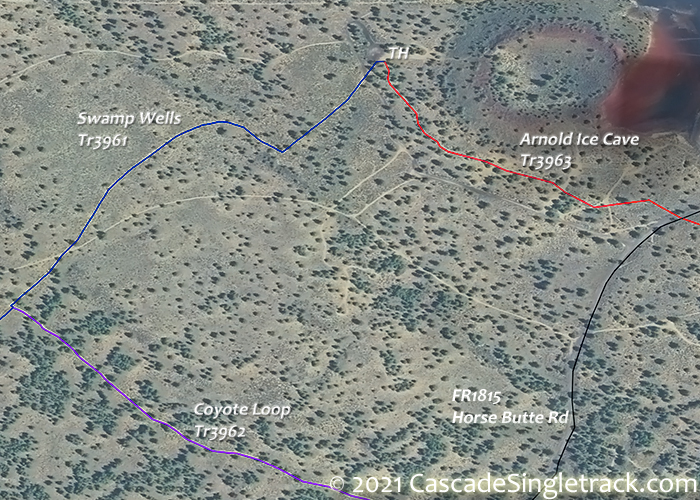
View of the Horse Butte TH, at Arnold Ice Cave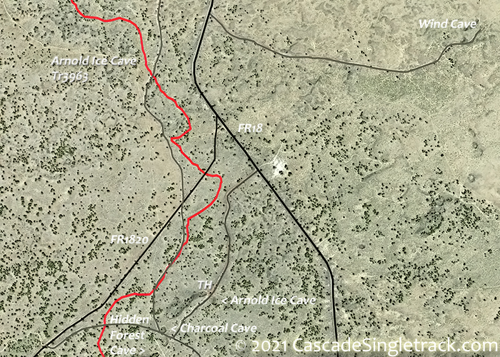
View of the Arnold Ice Cave TH and at Swamp Wells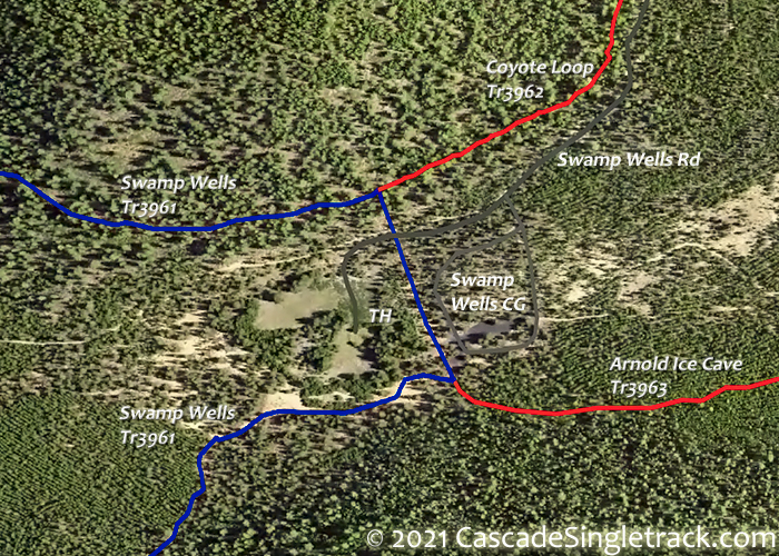
View of the Swamp Wells TH.
As FR18 is the only paved road in this area, Horse Butte TH gets the most use, but the Arnold Ice Cave TH is equally good.
Dings: Some of the local quarries are used as shooting ranges, so don't be too alarmed if you hear gunshots (unless of course you see bullets whizzing by). These trails get some equestrian use as well, so can become chewed up in wet, early season conditions. This trail system is near Bend and there is an extensive Orv trail system southeast of Arnold Ice Cave and the hundreds of fireroads in the area are popular with Orv as well.
Due to the lack of tree cover, expect high temperatures in August on Arnold Ice Cave Tr3963 and Coyote Loop Tr3962.
Arnold Alternative: A 25.5mi (2500' ascent) Swamp Wells Tr3961 to Coyote Loop Tr3962 CCW loop spends more time in the forest and avoids some of the pathfinding needed on the Arnold Ice Cave Tr3963 north of FR18.

Directions: 4mi on US97S from Bend, then go left onto FR18. Horse Butte: Go on FR18 for 5.9mi, then go left onto FR1815 and drive for 2.1mi, then go left to the Horse Butte parking area. Arnold Ice Cave: Go on FR18 for 12.1mi then go left on the Arnold Ice Cave Rd to the TH. View Larger Map. No Map?.

Loop Directions
got gps?
- TH: Head south from the Horse Butte TH on Swamp Wells Tr3961, passing the upper Coyote Loop Tr3962 TH at .5mi and crossing FR18 at 2.3mi. Pass the Bessie Butte Tr3968 intersection on the right at 2.4mi, a spur ride option. Cross several marked and unmarked doubletracks, including the FR1814 crossing at 5.5mi.
- 6.5mi: Ascend the northern Kelsey Butte flank (250' climb), then switchback and ride around the butte. Ride around a smaller, unnamed butte at 9.5mi. Cross FR1816 at 11.6mi, then pass the Swamp Wells Loop Tr33961.1 (a Coyote Loop Tr3962 connector trail) intersection at 12.1mi.
- 13.8mi: After riding around the base of a large butte (the ride summit), go right at the Coyote Loop Tr3962 intersection (another return loop option). Pass the Swamp Wells TH, then cross Swamp Wells Rd and go left onto Arnold Ice Cave Tr3963 (near the base of Swamp Wells Butte).
- 17mi: After crossing Orv20 several times, cross FR1820 then Swamp Wells Rd. Cross the Charcoal Cave Rd at 19.6mi then pass Arnold Ice Cave at 19.9mi and cross FR1820 at 20.2mi.
- 21.4mi: Cross a doubletrack then merge with it, just prior to crossing FR18. See Topo Map for this area, as there are a large number of unmarked double roads, so some pathfinding is required. Remain on doubletrack and go right at 22.1mi. Go left onto the singletrack at 22.3mi, towards Skeleton Cave, crossing the Skeleton Cave road at 23.6mi.
- 24.1mi: After merging with doubletrack, reach the Boyd Cave Tr3966 intersection on the left. Go straight then find the singletrack on the right at 24.3mi. Follow a drainage, then go west at 25.5mi and head back to the TH.

East Fort Rock OHV

See the NF OHV page for the OHV staging area info.
The area between Arnold Ice Cave and the Camp 2 Staging area is covered on the Area map.
- There are four staging areas, a campground/staging area, and four well-marked areas over 83mi of trails.
- The trail system is designed for Class I (Quads, 3-wheelers less than 50" wide and 800 pounds) and Class III (motorcycles) ATVs. Class II vehicles (side by sides, jeeps, etc) are allowed on routes designated as shared use only.
- All trails are open to horses, mountain bikes, and others, so please watch for others and share the trails.
- Staging areas: Road 2510 Staging Area, FR25 Staging Area, Camp 2 Staging Area, China Hat Campground, Ground Hog Rock Crawl and OHV Play Area, South Lava Staging Area. Staging areas have primitive facilities.
Trail Index
This Ride
Arnold Ice Cave Trail 3963, Bessie Butte Trail 3968, Boyd Cave Trail 3966, Coyote Loop Trail 3962, Fuzztail Butte Trail 3965, Skeleton Cave Trail 3967, Swamp Wells Trail 3961
Area
Bend Area
Bens Trail 50, COD Trail 71, Edison-Lava Trail 31, Elfin Magic Trail 45, Farewell Trail 26, Flagline Trail 41, Flagline Access Trail 40.1, Flagline Tie Trail 41.1, Funner, Grand Slam Trail 44, Kents Trail 43, KGB Trail 72, Mrazek Trail 32, MTB Trail 51, North Fork Trail 24.2, Phils Trail 42, Sector 16 Trail 27, Skyliners Trail 28, South Fork Trail 25, Sparks Lake Trail 4, Storm King Trail 48, Swampy Lake Trail 23, Swampy Loop Trail 23.2, Swampy-Dutchman Trail 40, Swede Ridge Trail 52, Tiddlywinks, Tumalo Creek Trail 25.1, Tumalo Ridge Trail 25.2, Voodoo Trail 46
Trail Rankings
Ranking consistently applied to all of the listed trails.
- Overall Rating: Ride quality and challenge
- Aerobic: Ascent challenge
- Technical Difficulty: Terrain challenge
- Steepness: Average incline
- Flow: Uninterrupted riding
- Elevation Change: Total elevation gain
- Ride Difficulty: Terrain challenge
