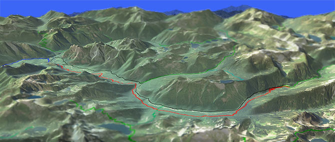
Middle Fork Snoqualmie River Tr1003
Twitter Search
#snoqualmieriver

Overall: 6
Aerobic: 4
Technical: 4
Steepness: 4
Flow: 7
Singletrack: 100%
Middle Fork Snoqualmie River Tr1003 is a moderate OAB ride near the Alpine Lakes Wilderness.
Type
OAB
Length
Avg: 27.5mi
Ascent
Moderate
Elevation Change
TH:1050'
Avg Ascent:5200'
Ascent Incline
4%
Duration
Avg: 5hr
Weather
Forecast
NOAA
popup
USFS
Trail
Review
Except for CCC Tr1264, all of the other trails shown access the Alpine Lakes Wilderness Area and so are off limits to bikes.
The forest service limits Middle Fork Snoqualmie Tr1003 bike access to odd numbered days in July and August, so be sure to check the forest service website prior to riding.
The climb is moderate from the TH to Goldmyer Hot Springs (11mi mark, near Goat Creek), with the 2mi beyond Goldmyer Hot Springs increasing in intensity.
Expect a lot of short climbs, which account for most of the elevation gain on this trail.
The trail parallels FR56 and is moderate enough to ride in both directions, although some choose to ascend FR56.
Goldmyer Hot Springs is run by a nonprofit group, charging a fee to use the hot springs, an attraction not usually found on a mountain bike trail.
In addition to area campgrounds, there are a number of camp sites along Middle Fork Snoqualmie Tr1003.
Directions: NW Forest Pass required right at the TH. Exit #34 from I-90. Drive north on 468th Avenue. Go .6mi then turn right onto SE Middle Fork Road FR56. The Middle Fork trailhead parking lot is on the right side of the road at 11.5mi. View Larger Map. No Map?.

OAB Directions
odd day to ride
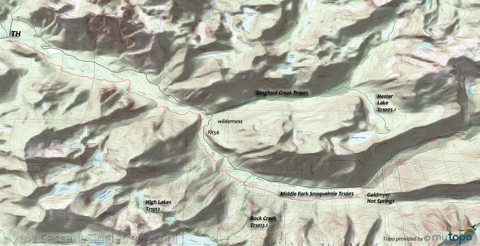
Snoqualmie River Area Topo Map
- TH: Cross the suspension bridge and dodge pedestrians for the first 3mi, over a trail surface which is more gravel than singletrack.
- 3mi: Cross small, bridged streams, near the river.
- 5.6mi: Bailout near Dingford Creek which crosses Middle Fork Snoqualmie River to access FR56. Rock Creek bailout at 8mi, then cross Thunder Creek at 9mi.
- 10.6mi: Pass Goldmyer Hot Springs, then reach another FR56 bailout.
- 13.8mi: End of trail, unless continuing on Dutch Miller Gap Tr1030 to the wilderness boundary.
Alpine Lakes Wilderness Hiking
The Area Topo Map shows the Garfield Mountain hiking trails, easily accessible from FR56.
From FR56, Rock Creek Tr1013.1 crosses Middle Fork Snoqualmie Tr1003 at the 8mi mark, then switchbacks through the steep, rocky Rock Creek drainage to Snow Lake, at the intersection with High Lakes Tr1012 and Snow Lake Tr1013. There is enough cliff exposure and otherwise challenging terrain to make this a technical hike.
Many hikers ascend Snow Lake Tr1013, continuing on High Lakes Tr1012 to Gem Lake, so expect a lot of day hikers on that route. When approached from I-90, at the top of the ridge above Snow Lake there is a large rock outcropping which is a popular destination for day hikers. High Lakes Tr1012 gets less use between Gem and Wildcat lake, so an extended hike offers more solitude.
Beyond FR56, Dutch Miller Gap Tr1030 ascends to the 'Dutch Miller Gap' saddle at the forest boundary with Wenatchee NF, then becomes Dutch Miller Gap Tr1362 and continues to the PCT. The trail offers a spectacular view of the Bears Breast Mountain and Summit Chief Peak, with Williams Lake Tr1030.1 and Lake Ivanhoe spurs.
Dingford Creek Tr1005 ascends alongside the creek to Myrtle Lake, with a Hester Lake Tr1005.1 spur leading to that lake, on a bench near the Mount Price peak. Hester lake has several campsites.
The rough FR5630 doubletrack leads to Snoqualmie Lake Tr1002, passing the unmaintained Honey Lake Tr1263 and Marten Lake Tr1006 spurs along the way. Snoqualmie Lake Tr1002 passes Deer and Bear lakes before turning into Dorothy Lake Tr1072, with a Nordrum Lake Tr1004 spur. Snoqualmie Lake and Dorothy Lake are two of the largest lakes in the area, with ample fishing and camp sites. Marten Lake Tr1006 is often overgrown with brush and mostly used for lake fishing.
To the south, Pratt River Tr1035 / Pratt Lake Tr1007 connects to Denny Lake Tr1011 / Denny Creek Tr1014, for either a gradual Pratt river valley hike or something much more challenging starting from I-90.
The too-accessible (but popular with families) Talapus Lake Tr1039 accesses Talapus and Olallie Lakes. As with all of the I-90 trails, expect a lot of day hikers.
The 2.8mi Granite Mountain Tr1016 offers a steady 3100' ascent, which leads to one of the last operational lookout towers in the forest, so just imagine the view...
A Denny Creek CG hike, Denny Creek Tr1014 passes Keekwulee and Snowshoe Falls between the Denny and Low mountains, before ascending to Hemlock Pass then descending to the Melakwa Lake basin and Denny Lake Tr1011. Bedrock slabs create a natural waterslide in Denny creek.
A narrow trail with some cliff exposure, Kaleetan Lake Tr1010 is a well established spur which wanders away from the congested areas of the Pratt and Melakwa lakes.
Trail Index
This Ride
CCC Trail 1264, Middle Fork Snoqualmie Trail 1003
Wilderness
Bandera Mountain Trail 1038.1, Denny Creek Trail 1014, Denny Lake Trail 1011, Dingford Creek Trail 1005, Dorothy Lake Trail 1072, Dutch Miller Gap Trail 1030, Granite Mountain Trail 1016, Hester Lake Trail 1005.1, High Lakes Trail 1012, Honey Lake Trail 1263, Island Lake Trail 1009.1, Kaleetan Lake Trail 1010, Marten Lake Trail 1006, Mason Lake Trail 1038, Mount Defiance Trail 1009, Nordrum Lake Trail 1004, Pratt Lake Trail 1007, Pratt River Trail 1035, Rock Creek Trail 1013.1, Snoqualmie Lake Trail 1002, Snow Lake Trail 1013, Talapus Lake Trail 1039, Williams Lake Trail 1030.1
XC Ski
John Wayne Trail, Kendall Ridge XC Ski Trail, Silver Peak XC Ski Trail
Campgrounds
Commonwealth Campground (I-90), Denny Creek Campground (I-90), Mine Creek Campground (FR56), West Fork Campground (FR6412)
Trail Rankings
Ranking consistently applied to all of the listed trails.
- Overall Rating: Ride quality and challenge
- Aerobic: Ascent challenge
- Technical Difficulty: Terrain challenge
- Steepness: Average incline
- Flow: Uninterrupted riding
- Elevation Change: Total elevation gain
- Ride Difficulty: Terrain challenge


