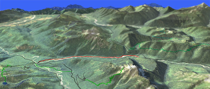
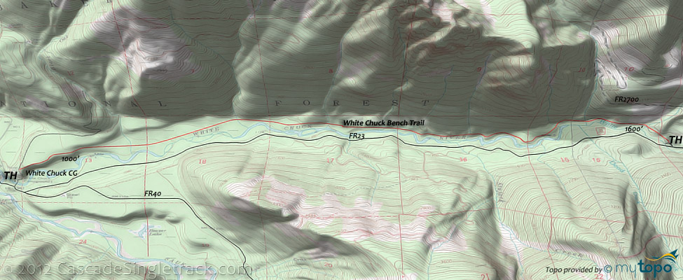
White Chuck Bench Tr731
Twitter Search
#whitechuckbench

Overall: 5
Aerobic: 4
Technical: 4
Steepness: 4
Flow: 8
Singletrack: 100%
Nestled between White Chuck Mountain and Pugh Mountain, the Darrington Washington White Chuck Bench Trail meanders through alder and second growth forest alongside the White Chuck river.
Type
OAB
Length
Avg: 11mi
Ascent
Easy
Elevation Change
TH:1050'
Avg Ascent:1700'
Ascent Incline
3%
Duration
Avg: 2hr
Weather
Forecast
NOAA
popup
USFS
White Chuck Bench Tr731 skirts along the ridge above the river then descends to Black Oak Creek, followed by 8 additional creek crossings before terminating at FR23.
This is a relatively easy ride and certainly not a destination trail, but very accessible and at a low enough elevation for an early season ride.
Aside from the White Chuck CG, there are many camping options near Elliot Creek Tr647, south of the North Fork Sauk River Guard Station.
Directions: NW Forest Pass required right at the White Chuck Campground TH. From Darrington take the Mtn Loop Hwy FR20S till it crosses the Sauk river, then turn onto FR22 to the Which Chuck CG TH. View Larger Map. No Map?.

OAB Directions
you might get wet
- TH: Not much direction needed for this one. Start from the White Chuck campground and ride upstream to the FR23 TH, then return.
- 1mi: Cross Black Oak Creek. Cross 8 additional creeks, spaced about every .5mi.
Glacier Peak Wilderness Hiking
Easily accessible from the metro Seattle area, the Glacier Peak Wilderness is very popular for day hikes and backpacking.
The Area Topo Map shows the hiking trails in the White Chuck and Sauk River valleys.
Mount Pugh Tr644 ascends 1300' to the 3 acre Lake Metan at 1.4mi, then switchbacks to the sharp-ridged Stujack Pass at 3mi. Expect steep snow into August and plenty of loose talus, making the upper section of this hike somewhat technical.
From FR2086, the Peek-A-Boo Lake Tr656 doubletrack narrows to a singletrack trek through old growth forest, traversing a ridgeline to the lake. The lake has some camp sites on the NE side and is surrounded by boulders and marshy terrain.
A major PCT connector, White Chuck River Tr643 gets the most use of all the Glacier Peak Wilderness trails, and can be combined with the 15.7mi Meadow Mountain Tr657. Kennedy Hot Springs has a few campsites, a base camp for a day hike to Lake Byrne. At 5x5, the 95 degree springs are relatively small.
From Kennedy Hot Springs, Lost Creek Ridge Tr646 passes Lake Byrne then follows the ridgeline to Bingley Gap, before descending to FR4900. There are a few camp sites at Round Lake and expect deep snow along the steep ridgeline through July, requiring some technical hiking skills, stamina and pathfinding abilities.
Further south, North Fork Sauk Tr649 is another major PCT connector, gradually ascending through cedar forest, with camp sites along the trail, before steeply switchbacking the flank of White Mountain. Can be combined with Pilot Ridge Tr652 into a 26mi loop.
To the north, the PCT connects to the steep, wet Milk Creek Tr790, which leads to the FR26 Sulphur Creek CG, a White Chuck River Tr643 shuttle option.
Trail Index
This Ride
White Chuck Bench Trail 731
Wilderness
Beaver Lake Trail 783, Bedal Creek Trail 705, Circle Peak Trail 638.1, Crystal Lake Trail 638, Elliot Creek Trail 647, Kennedy Ridge Trail 639, Lost Creek Ridge Trail 646, Meadow Mountain Trail 657, Milk Creek Trail 790, Mount Pugh Trail 644, North Fork Sauk Trail 649, Pacific Crest Trail 2000-K, Pass Lake Trail 645, Peek-A-Boo Lake Trail 656, Pilot Ridge Trail 652, Sloan Peak Trail 648, White Chuck River Trail 643
Campgrounds
Bedal Campground, Buck Creek Campground, Chocwich Campground, Elliot Creek Campground, Old Trail Campground, Sulphur Creek Campground, White Chuck Campground, White Deer Campground
Trail Rankings
Ranking consistently applied to all of the listed trails.
- Overall Rating: Ride quality and challenge
- Aerobic: Ascent challenge
- Technical Difficulty: Terrain challenge
- Steepness: Average incline
- Flow: Uninterrupted riding
- Elevation Change: Total elevation gain
- Ride Difficulty: Terrain challenge


